

Practical 3D Scanning with Dot3D Pro
What is 3D Scanning?
3D scanning has come a long way since the first ever object to be ‘scanned’ using students, paint and rulers. Even with the advent of more advanced techniques in the mid-1990s, 3D scanning was still slow and limited to small objects that could fit on a turntable – often also constrained by the data capacity of current generation storage and compute. Once we progressed past brute force student labor, in the early 1990s, scanning still meant bulky laser scanners tethered to very powerful computers.
Scanning an object or scene in 3D requires a combination of technologies to work well together. For starters, it requires that you have a way to scan every surface of an object or scene – which means objects either need to be placed on a turntable or similar rig so they can be moved around in front of the camera, or that the camera can be moved around the objects or scene. Either way requires some method of registering each image or separate frame with the next in order to build up a complete 3D picture of the object. Your choice of camera type also affects how the 3D scan is built up – you can either use a 2D camera and specialized software to build up the object using post-processing, or you can use a depth camera like the Intel® RealSense™ D415 along with software from one of our partners like DotProduct for a more real time result. The downside of the 2D camera method (also known as photogrammetry) is that there are no guarantees – you might not know for hours or days whether your painstakingly taken images will be resolved into an accurate 3D model.
Practical uses for 3D Scanning
DotProduct has been building industrial 3D scanning applications for many years, using a variety of sensors and rugged tablet solutions to enable a number of interesting use cases – we’re going to talk about just a couple of those today, but these are by no means the only potential use cases for this technology.
Construction is one of the biggest industries in the United States (and worldwide). In the US alone, there are more than 7 million people employed by this gigantic industry. Every structure that is constructed is a miracle of design, technology and skilled labor. With such complex constructions however, come a wide variety of problems. For every building – especially large, multimillion dollar constructions, there are architectural blueprints, construction plans and vast amounts of data. Managing that data is often managed by software known as Building Information Modeling – digital representations of physical and functional characteristics of a facility. This is a shared knowledge resource for information about a facility forming a (hopefully) reliable basis for decisions during its life-cycle from earliest conception to demolition. Not only does a model like this govern what happens during construction, but it also helps with things like modifications or repairs to facilities – buildings can last for decades and will often go through multiple different uses along the way, and this data set is an important resource.
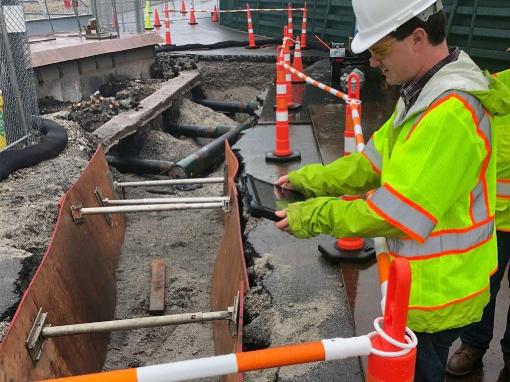
Image courtesy Bond Brothers Construction
BIM data is great, as a source of truth about a building, as a set of directions for how that building will be constructed, but it’s only as good as the accuracy of the data. How do you guarantee that the building was constructed in the way that the blueprints said it should be? What if, for a variety of reasons, the smart choice for a contractor or owner is to make field choices to the design, to substitute equivalent materials or equipment that might be more readily available or cost effective? If these kind of routine changes go undocumented, it can affect or disrupt later efforts. As a building is being constructed, what is the best way to measure and track the accurate completion of milestones? With a digital model of the plan, the ideal solution is to also have data from the real world construction to compare. Today that’s frequently done using cellphone cameras to photograph wiring or ductwork before walls are closed, for example. But this is a far from perfect solution – without a way to determine where photographs were taken, or a good way to manage the vast quantities of data this could generate, this is at best minimally useful and extremely high friction. Delivering this information in a timely way is also important – a good answer today is far more valuable than a great answer tomorrow. Tomorrow is too late for the very time sensitive construction industry – where time is literally money.
How does it work?
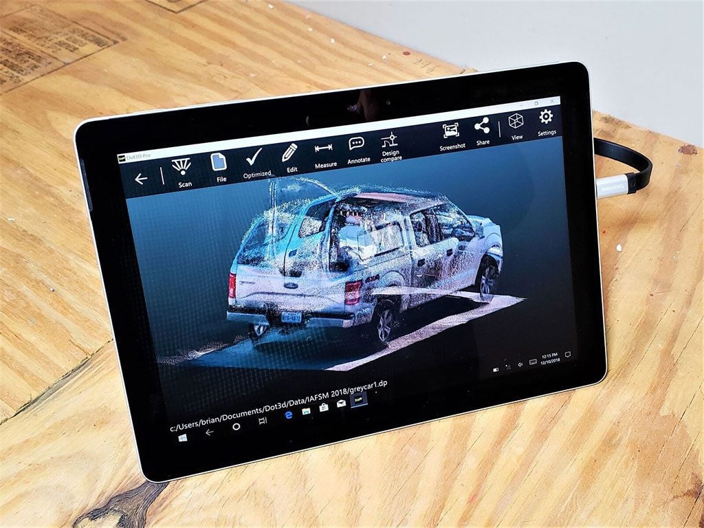
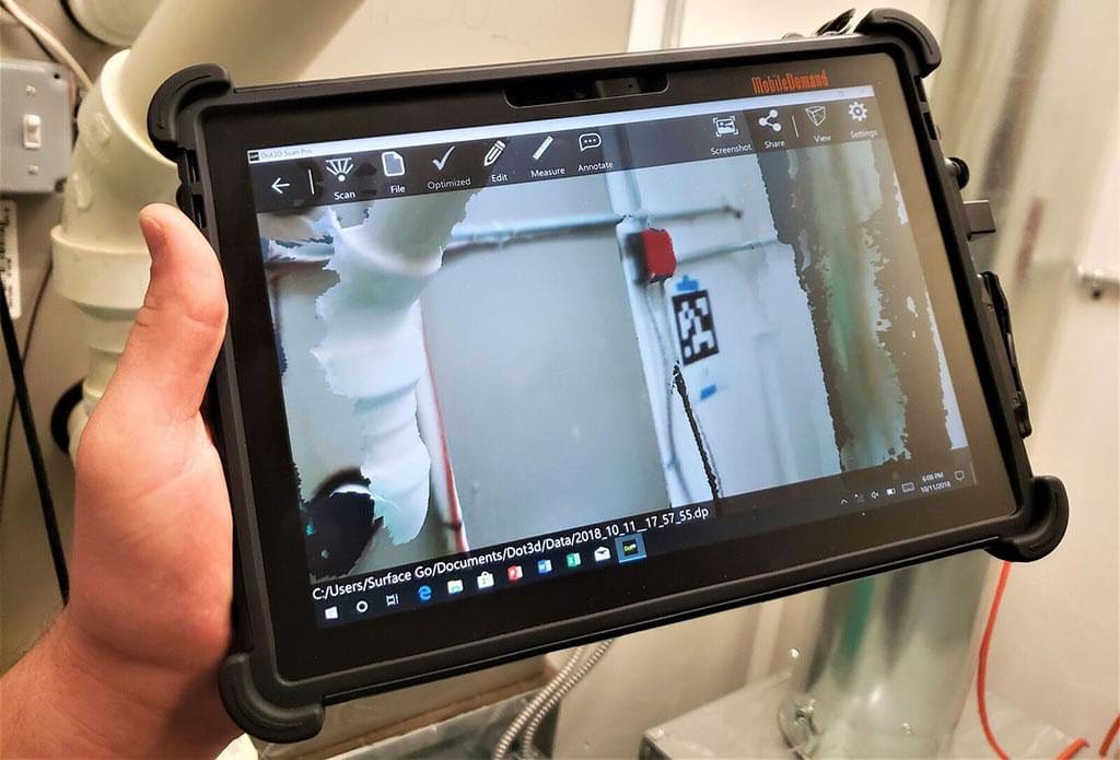
The ideal solution would be easy to use, registers the location of any images taken, and allows comparison directly to the original digital plans. Enter Dot3D Pro. DotProduct, the company behind Dot3D, have been creating 3D scanning solutions for a number of years now. Their latest software offering allows a user to take an Intel® RealSense™ Depth Camera, attach it to the back of a tablet, and then use that combination to quickly and easily create a 3D scan. The Intel RealSense technology can also be embedded into ruggedized tablets designed for use in the field.
Mobile Demand ruggedized tablet with integrated Intel RealSense Depth Camera D415
As you move around the space, the display shows a very intuitive interface – you “spray paint” your scene with the camera. Areas that are white or transparent haven’t been full scanned where yellow and green are good. As you move, you can also take high-resolution 2D photos of any important details, which register exactly to the appropriate spot on the 3D model. Instead of multiple disconnected images, you end up with an accurate 3D model with properly associated 2D images. The model is accurate enough for measurements to be taken at any time, on site in the field.
The final important step of the process here is being able to compare the scanned model with the planned model – which happens within the Dot3D Pro app. Their Design Compare feature allows the use of all industry standard file formats for comparison – and with small scan file sizes and fast local processing, internet connections aren’t necessary. Evaluations can happen directly onsite or remotely, depending on where the important stakeholders are located, instead of upon technological limitations. Once the scanned model is registered to the design model it can be uploaded to the design database allowing the model to be refreshed.
Other practical uses
Construction is just one use case for 3D scanning with Dot3D Pro – there are many other cases where having a portable, easy to use 3D scanning solution is useful. Crime scene documentation, for example. Investigators can limit the number of people needed to enter a crime scene to record it, instead, one person and a tablet can create a perfect and dimensionally accurate record of every object in a scene which can then be studied and analyzed by the investigative team, even viewed by a jury at any time. As people who live in the 3D world, any 2D diagram will always be inferior to 3D reconstructions of our world – we intuitively grasp 3D space far better than 2D representations. These 3D scans enable us to really understand a scene or a space without any context necessary.
These are just a couple of use cases for this technology, though there are many more. If you are interested in checking out Dot3D Pro, please visit their website for more information.
Don’t forget to visit the DotProduct website for more information.
Subscribe here to get blog and news updates.
You may also be interested in
In a three-dimensional world, we still spend much of our time creating and consuming two-dimensional content. Most of the screens
A huge variety of package shapes, sizes, weights and colors pass through today’s e-commerce fulfilment or warehouse distribution centers. Using
Let’s talk about how Intel RealSense computer vision products can enhance your solution.